
His efforts have been instrumental in pushing for critical infrastructure and resources to enhance safety in this high-risk region.
Drones have become integral to WSAW’s work, offering a unique perspective on Waikōloa and its landscapes. By documenting wildfire hazards from above, these technologies are helping to raise awareness of existing threats and accelerate the implementation of safety plans.
In an interview with the ViewPoints team, the third-place winner of our #DecadeWithDJI contest discusses his journey with WSAW, the crucial role drones play in wildfire prevention, and his vision for a safer, more resilient community.
Can you share your background and what inspired you to start using drones for wildfire safety?
Certainly! I first got interested in model aviation as a kid back in the 90s through competitive rubber band-powered indoor free flight models. When I moved to Hawaii with my wife, I discovered that there aren’t any true “indoor” venues available for that type of model aviation. My wife is a photographer, and I had always been interested in drones, so we purchased our first DJI drone in 2018 to offer aerial video and photos as part of her packages.
In August 2021, the largest wildfire in Hawaii's history came within three miles of our house, and we were forced to evacuate with our one-year-old baby. Two years later, as the fires ravaged Lahaina, we anxiously watched as fires burned on our island as well. These two events were psychologically transformative for me.
Although we have successfully dodged disaster thus far, our little corner of Hawaii has been overlooked for a long time. While it is beautiful, the memory of it burning in the past and the thought of it happening again is inescapable. I decided the best therapy for myself would be to start taking videos of our situation. If a picture is worth a thousand words, a video is priceless. Sharing my concerns with people whose feedback I trust is the best way to address anxiety. I hope that by bringing awareness to our hazard, we’ll motivate decision-makers, private landowners, and governmental entities with jurisdiction in the area to make wise decisions about our safety.
What role do you play within the Wildfire Safety Advocates of Waikōloa (WSAW)? Can you please tell us more about the group?
I co-founded WSAW in early 2024 with my wife in response to the lack of progress on a critical need for our community: a second road. Our village of approximately 7,400 residents is in one of the most high-risk areas for wildfire in the state, and only has a single road in and out. Despite governmental committees identifying the need for a second road over 20 years ago, no progress has been made. I realized what’s really needed is advocacy. The squeaky wheel gets the grease, and we’ve certainly turned up the volume of the squeaking a lot recently.
We’ve also identified several other wildfire safety-related deficiencies in the area. In some cases, we’re advocating to private landowners for enhanced land management practices, and for other areas, we’re coming up with solutions on our own. No one has made an evacuation plan for our village, despite us having evacuated as recently as 2021. We’re going to fix that ourselves.

How do you use drones to map out vulnerabilities and identify high-risk areas for wildfires?
The high-risk areas are already well known, but that information is distributed unevenly, and fire risk is very much in the back of many residents’ minds.
For example, there are a few interior lots in the village owned by the HOA and County that are completely enclosed by owner-occupied houses. Until very recently, these lots had never been maintained. Some residents had started to use hard-to-access corners of these lots as dump sites, which had grown into a fire hazard. However, if you don’t live next to the lots, you might have never known about their existence.
That’s where drones come into play. Publicly posting aerial footage of these lots has really expanded awareness of the hazard beyond those who live next to it. In my opinion, this accelerated ongoing plans to clear and maintain them.
How have drones impacted WSAW’s work in wildfire prevention?
Drones are absolutely vital for wildfire prevention efforts. Widely sharing the visuals of how stark our landscape is has been transformative. The drone videos have provided a clear sense of scale to this problem that is lacking from our normal ground’s-eye view.
What specific features of the drones have proven most beneficial in your wildfire safety efforts?
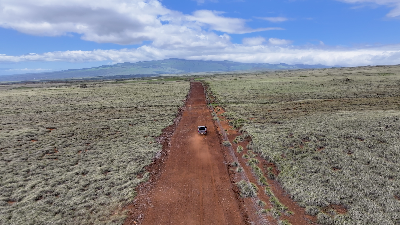
This is a tough question, but I’d have to go with the in-flight stability of DJI drones. Waikōloa Village is situated in a wind tunnel between Kohala Mountain and Mauna Kea. The prevailing trade winds are focused through this tunnel, and we have a very consistent 10-15 mph wind that can regularly have gusts in the 20-30 mph range.
All the drones I’ve used have handled the winds admirably, but the Mavic 3 Pro was absolutely rock solid between smart shot orbits, pre-programmed flight paths, and following the truck as we drove down the fire breaks. Without that ability to withstand gusting winds, I’m not sure we’d ever be able to accurately document the village and surrounding areas!
To learn more about the Wildfire Safety Advocates of Waikōloa (WSAW),
visit www.wildfirewaikoloa.org.
|
Over the past few weeks, we invited the drone community to share their stories as part of our #DecadeWithDJI campaign. The ingenious, creative, and meaningful use cases we received have inspired us to launch a content series of the same name. This series celebrates the drone pioneers, communities, and organizations that have built careers, businesses, and demonstrated positive impact through our drones. Follow the series here. |